Parks That Matter

A few months ago I was asked by my friend and colleague Antonio Gomez – Palacio  to contribute to a feature series he was preparing for the Ontario Planning Journal on the subject of ‘Designing the Public Realm’.  I was compelled by the editorial approach he was taking and was well aware of the intelligence he would bring to the conversation not to mention the other contributors he would bring to the project.   The following is an exerpt of my piece, but I would encourage you all to read the entire series.   It is first rate and brings a number of stellar so-called peripheral voices to the discussion.

Here is the link to the series. and the unedited content of my piece is below:

http://ontarioplanners.ca/getattachment/7b416459-67cc-4e7a-987e-7bd6db2dc701/Ontario-Planning-Journal-September-October-2016-Vo.aspx

Parks That Matter

I am both a planner and designer of the public realm.  This means of course, that I am also an advocate for it.  It is something I fight for every day.

When I started my work as the Manager of Parks and Open Space Planning for the then Town of Markham in 1991, the term ‘public realm’ did not factor into the planning lexicon of most cities.   Markham was no different.   It was essentially a bedroom community of Toronto that was under enormous development pressure.  Its physical environment was largely comprised of quaint heritage village main streets surrounded by subdivisions, strip malls, shopping plazas and business parks.

In those days, new parks acquired through the development approvals process were most often considered little more than lands required to meet the park dedication requirements of the Planning Act, or to deliver a particular recreation program.  Most often, they came into being as residual land.  Spaces left over after the roads, blocks and lots had been drawn.  Valley lands, woodlots and those same parks were all potentially valuable city public realm assets but were most often hidden from public view.  It was common practice to essentially privatize public assets by turning the city’s back to them.  This was the most efficient use of land, and it was the most profitable way to develop.

At least for Markham, one decision changed all this for the better.

In the mid-nineties, Markham invited The New Urbanism into their world.  This was partly in response to rapid growth and partly in response to development proposals that harkened to ‘more of the same’ – un-navigable cul-de-sacs and crescents, and neighborhoods that really didn’t feel much like neighborhoods.    It was also in response to higher density developments clinging to the post-modern principle of ‘buildings in a park’ or in the case of retail development, buildings in a parking lot.

City leaders in Markham understood that with the enactment of Official Plan Amendment 5, they had one chance to expand their urban boundary but to do it through the planning and design of more sustainable and dynamic neighborhoods. Through the leadership of Planning Commissioner Lorne McCool, Planning Committee chair David Tsubouchi and a smart Mayor and Council, they came to see the New Urbanism as the way to do it.

This decision took a leap of faith on the part of Council and ultimately drove the city to re-think everything.  Civil and transportation engineering standards, zoning and land-use standards, park planning and design standards as well as landscape and streetscape design standards.  It placed urban design at the centre of the planning process, rather than at the edges of it.   And to our great good fortune, at the centre of the New Urbanism one finds the public realm.

It was not until I left Markham in 1998 however, that I fully came to appreciate what a well-planned public realm offered me as a landscape architect.   It offered a chance to design places that would truly matter to future residents.  Places that not only delivered on program and functionality, but also celebrated the unique qualities, values and aspirations of the people who would ultimately make these communities their home.   It offered a chance at public places that would meet their full potential as ‘the armature’ of a community.

The following principles are for me, fundamental to guiding the programming and design of parks, and open spaces in these new communities:

IT IS ABOUT WHAT YOU SEE

Conventional suburban communities are inherently disorienting.  Looping crescents bisected by cul-de-sacs leading nowhere.   A well organized public realm solves that problem through the deliberate anchoring of views.   Streets will most often terminate at a roundabout, park, natural feature or at an iconic building such as a church or school.  This structural dynamic makes a neighborhood inherently unique and navigable.  You know where you are because of what you see.  For the designer, this opens the opportunity to anchor those views with park architecture, entrance gates and signage, trailheads, public art or recreational features such as playground apparatus.

its-about-what-you-see-3S:ProjectsCornell Parks Phase I (P) 26069PRenderingPdfCopy

The Grand Cornell Clock Tower anchors the view of the main street and serves as a gathering or meeting place for residents.

IT IS ABOUT PUBLIC / PRIVATE SYNERGY

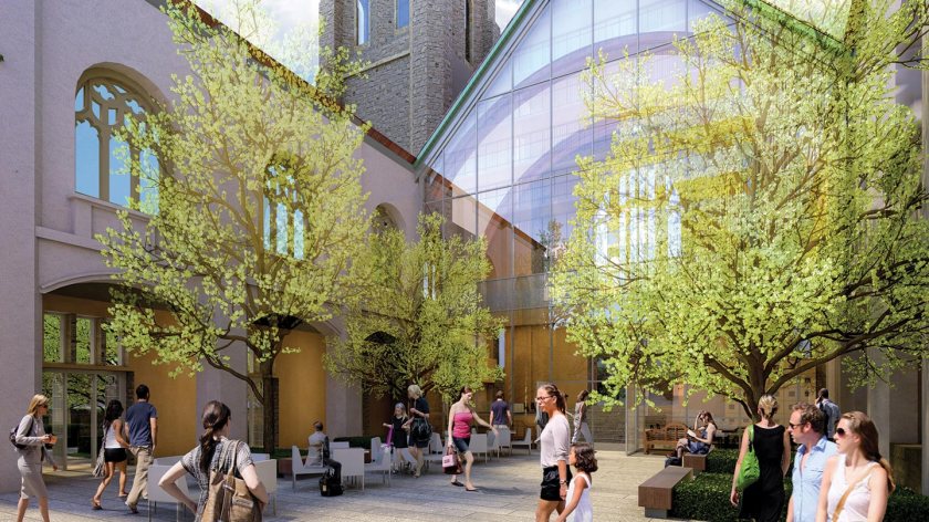
Great public spaces are most usually a product of built form that is in proportion to the spaces they frame.  They are also a product of ground floor land uses that reinforce the activity within that space.  Built form and land use are critical to ensuring animated public spaces.  It is the role of the designer to ensure that the landscape takes full advantage of that symbiotic relationship.  Residential uses will call for a very different solution than retail or commercial uses.

S:ProjectsVIVA Greenway (P) 11027PRenderingSourcesLSeries B

The Civic Mall in Markham Centre is a linear open space that will ultimately serve as a primary pedestrian east/west spine through Markham Centre.  Four plaza spaces animate the entrances to adjacent buildings – both residential and commercial/retail uses.

IT IS ABOUT DISCERNIBLE NARRATIVES

Perhaps more than any other design profession, Landscape Architecture offers the opportunity to incorporate metaphor as the under-pinning of a project.   Narratives can be reinforced simply through the geometry of a public space, or by more substantive moves that can be made through the expression of natural or cultural history or both.   It can be expressed through the design of single installations like public art, or through a more integrated approach where public art, park architecture, play, landform and materiality all work together in telling one story.   In each of these cases, it is important that the narrative be discernible or easily understood. It must mean something to stakeholders.

discernable-narratives-1discernable-narratives-2

The Metroplace Orchard Park in North York is a one acre public/private open space that celebrates the natural history of the site through the use of both public art and landscape. 

IT IS ABOUT INTENTIONAL and ACCIDENTAL PLAYFULNESS.

Parks and open spaces that enjoy a high visual profile offer an opportunity to re-imagine play and its role in defining recreation.  The design of new parks must not only be about play but also about ‘playfulness’.   The days of the conventional playground defined by off-the-shelf play equipment are ending.  Play does not stop there.  For many new communities, play can also mean exploration, imagination and whimsy.

In 2012 we designed a new five acre park in Thornhill City Centre that included a two-acre degraded woodlot.  After many management improvements the woodlot and park were opened to the public. Within a week, children from the neighborhood had constructed half a dozen from fallen dead tree limbs.   Kids have a funny way of deciding for themselves what ‘play’ is.

intentional-playfulness

Pattern Park in Richmond Hill asks visitors to find twelve patterns found in nature, in the materials and finishes within the park.   

IT IS ABOUT OUR COEXISTENCE WITH NATURE

Whereas natural features such as woodlots, ravines and valley lands used to be peripheral to community design, they are now formative and structural.  By making these features the centre of new communities, the demand for public access becomes inevitable.  That said, cities must intervene and design these features in a manner that balances demand for public access with ecological function and habitat conservation.

S:ProjectsMarkham Greenlands Master Plan Implementation 29026

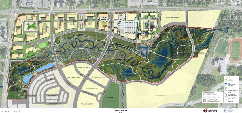
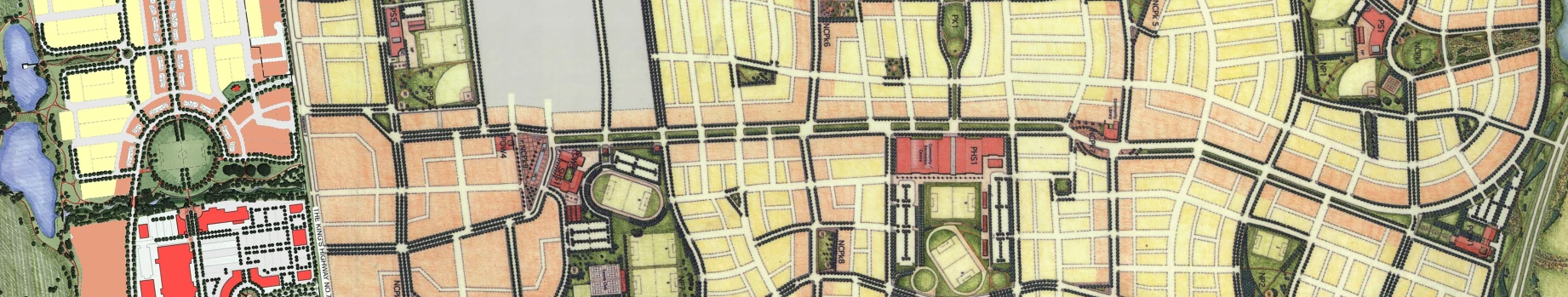
The focal point of Markham Centre is the Rouge River – a large valleyland feature that bisects the city centre.  Its high profile location demanded a management plan that would balance human use and enjoyment with ecological and habitat function.  

IT IS ABOUT PEOPLE

A well-planned public realm is more democratic.   Its design therefore demands a rigorous public participation design process.  It demands a process that unleashes the hopes and aspirations of stakeholders.   A process that can result in a public realm that reflects the people it serves.  The challenge is to inspire – to represent  the notion of beauty and meaning as a reflection of who we are.

about-people-1about-people-2

 Leitchcroft Square is a 1 acre urban park in Thornhills Galleria community.  The design evolved through an extensive community consultation process that resulted in a tai chi park complete with a Reiki pebble path. 

 IT IS ABOUT SUSTAINABILITY

It is fortuitous that the increased interest in the public realm has coincided with the growing interest in sustainability. Low Impact Development (LID) techniques are increasingly being incorporated into the public realm.   Curb-side rain gardens, infiltration galleries in parks, permeable pavements and the use of photo-voltaic systems are changing how we view the public realm.  It also has the potential to significantly reduce demands on municipal storm water systems as well as maintenance and operating costs.  These techniques also serve to express a City’s commitment to sustainability and their willingness to avoid the temptation to  ‘bury’ money.

 03

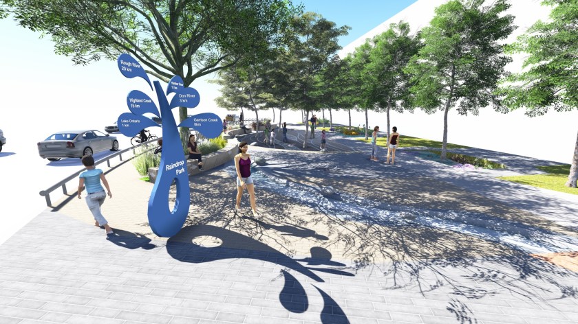
Raindrop Plaza Park in Toronto is a small urban open space designed to meet Toronto Water’s West Weather flow Management Plan and Toronto Green Standard objectives to “manage rain where it falls”.   The project incorporates rain gardens, permeable pavements and storm water capture for the irrigation of trees. 


Advertisement

Markham Uptown: A Complete Community in the Making

I have been involved in the planning and design of Markham Centre for over 25 years.   First, as the Manager of Parks Planning and Urban Design for the then Town of Markham (now the City of Markham), where I helped to shape the secondary plan and many of the public policies that would drive the project.

After leaving public service, I was fortunate enough to have been retained by Times Group Corporation who had acquired a large chunk of the Markham Centre lands from Hullmark Developments.  My work since has been as part of a diverse team bringing the original vision for Markham Centre to life.

The plan for Markham Centre was developed in part, in response to the Province of Ontario’s ‘Places to Grow’ initiative, which envisioned a transformation of the suburbs of Toronto from bedroom communities, to thriving high density nodal developments supported by transit and compact infrastructure.  This could be Markham’s new ‘downtown’.  But only if we got it right.

The first 3 phases of the development have been constructed and feature a number of innovations as well as set the stage for future phases.  It is safe, I think, to say that Markham Uptown can be distinguished by one leading characteristic.   It is a Complete Community. 

IMG_0978IMG_1839_edited

Much has been said in recent years about ‘complete streets’ but it occurs to me that complete streets aren’t even possible in the context of suburban intensification, without first delivering ‘complete communities’.

Markham Uptown is such a community.

The first 3 phases have delivered all of the ingredients that I suggest are vital to the creation of a complete community.

They are:

  • Land uses are mixed to include employment, office, retail and residential.  An elementary school will be provided in future phases as will an office precinct at the west end of the site opposite City Hall Other land uses such as community centers and high schools are provided on other lands within Markham Centre as a whole.

IMG_1826_edited

  • City blocks are a very pedestrian friendly 90 – 120m long.
  • Building loading and servicing areas are screened from view and are assembled along a private laneway which also helps to break up the blocks into smaller architectural units.
  • The first main street (Birchmount Road) is animated on both sides with at grade retail
  • The retail is supported by on-street parking as well as interior parking lots that are mostly screened from public streets by built-form and landscaping.
  • Bicycle lanes are a dedicated form of transportation on the major roads
  • The entire site is serviced by regular regional transportation and it is a 15 minute walk through the Rouge Valley to the Markham GO Train station to the south.
  • All buildings are LEED Gold and bird friendly
  • At grade residential uses animate the street with principle unit entrances, decorative fencing and gates.

IMG_0292_Revised

  • Extensive Green roof technology is fully employed in each phase

IMG_3203

  • Residential towers offer outdoor rooftop amenity spaces that overlook the Rouge Valley.

IMG_0975

  • Rain water harvesting on each block meets water balance targets and allows for storm water re-use in irrigation and building plumbing
  • LID initiatives include the use of permeable pavements, infiltration galleries and whole system cisterns that delay the reintroduction of storm water run-off into the Rouge River and allow for the settlement of particulates and the cooling of run-off.   These operate in place of the traditional storm ponds that are a maintenance headache and consume valuable land.
  • Street tree soil volume targets of 30m3/tree are met with either increased boulevard soil depths, or in the case of trees in pavement through the use of structural soil cells
  • The precinct is punctuated with 4 public open spaces.   Two 1 acre parkettes in the east and west neighbourhoods, a central plaza space which will serve as a focal gathering space for residents and a large east/west linear park that straddles the Rouge Valley.

There is little doubt that these features make Markham Uptown a unique development in the GTA, if not unique to the Province of Ontario and the country as a whole.  Markham Uptown will absolutely be made unique however, by its physical relationship to the Rouge Valley which bisects the Markham Centre lands.

support_rouge.jpg

The Rouge River is a large floodplain.   It is a wildlife corridor and important cold water fishery and it features a number of unique and rare plant species as well as geomorpholigical features.  It is also one of the key linkages in connecting the future downtown of Markham with Milne Dam Conservation Area and The Rouge Park to the east.

The plan for Markham Centre and Markham Uptown is to integrate the best of urban design with the very best in natural features protection and management.   This is accomplished through Markham Centre Greenlands Plan, prepared by our office.  After an exhaustive inventory and assessment of flora, fauna and hydrologic features, the greenlands plan recommended a number of interventions and improvements that would balance conservation and protection goals with  the inevitable demand for public access that would come with new development

These initiatives will be complimented by an interpretive program that heightens awareness around each unique feature of the corridor as well as preferred public protocols for interaction with the river.

The first phase of this work is now fully funded by the municipality and developer and will be undertaken in the not too distant future.

It is my view that Markham Uptown will be a uniquely complete community.  This is borne out by the success of the first three phases and the commitment of both the City and Developer to continue to ‘do it right’.   There is of course, more to do.

PROJECT TEAM

 Landscape Architecture and Urban Design:                    Schollen & Company Inc.

Architecture and Urban Design:                                Kirkor Architects and Planners

Planning and Urban Design:                                              Malone Given Parsons Inc.

Civil Engineering:                                                    SCS Development Consultants Inc.

City Building and The Legacy of Church Architecture in Toronto

I found it curious that both of the churches in Toronto where my father was minister were no longer active United Churches.   Mount Dennis United Church had recently been converted into an evangelical Filipino Church and Deer Park United Church was proposed to be partly demolished to make way for a new condominium.

OLYMPUS DIGITAL CAMERA
Deer Park United Church Before
6230575_orig
Deer Park United w. Condo
courtyard-interior-blue-diamond
Deer Park United w. Condo

I was certainly aware that United Church congregations had been dwindling in numbers over the last number of decades, but wondered just how deep the rabbit hole went.  If the trend is true for the United Church, is it also true for other places of worship?  What might this mean for Toronto, whose public realm is defined in large measure, by its vast number of churches – many of which are iconic structures that beautify and give life to streets and neighbourhoods?  What might this shift mean for other Canadian Cities who are no doubt, faced with the same statistical inevitability?

In its heyday, the United Church was second only to the Catholic Church in the number of churches it had constructed and operated in Toronto.    The United Church had 131 churches and the Catholic Church (of varying sub-denominations) had 133.  It appears that the vast majority of Catholic Churches remain intact and continue to operate as Catholic Churches.   This is not the case for the United Church of Canada.

In 1980, the UCC had a national membership of 389,492.   By 1990 that number had dwindled to 338,040 and by 2000 their numbers dropped to 270,361.    As of 2011 the membership sat at 166,936.  Roughly 42% of its 1980 numbers.

http://www.calgaryherald.com/life/Churches+keep+faith+congregations+steadily+shrink/9347983/story.html

GoogleEarth_Image
Eglinton United Church as a Condo

If one assumes that this decline has been distributed evenly across its ministry, then clearly the maintenance of 131 churches in Toronto would become an unsustainable challenge.

And so what has actually happened?   What are the numbers?*

team_5_lrg

Of the original 131 churches, 82 remain as originally constructed or as merged congregations that combined forces to save at least one of two buildings.  Another 10 churches have been redeveloped as both churches and other uses such as community centres, seniors residences and health centres.  Approximately 92 churches total remain intact as churches.  (70%).

It is also interesting that only 15 church sites have been demolished and replaced outright by some other land use. (11%)

Other changes include:

No. of churches taken over by other faiths:                                               6

No. of churches converted to condos or other residential uses:           9

No. of churches converted into schools:                                                      0

No. of churches converted into community theatres:                              1

No.  of churches converted into community centres:                               1

No. of churches expanded as a result of amalgamation:                          5

Based on these numbers it appears that the decline of the church has been managed with a great deal of creativity and innovation.   There seems to have been a concerted effort by the City and Church to maintain the buildings as physical structures within our public realm and this, I think, should be applauded.

GoogleEarth_Image3
The Former St. James Bond United Church

One concern of note however is the fact that so few have been converted into schools or community centres.   It seems to me that those public uses would serve a greater good than converting to condos or other ‘singular’ uses.   Those public uses would not only allow for the maintenance of iconic architecture, but also ensure that they remained focal points for community use and enjoyment.

OLYMPUS DIGITAL CAMERA
The Bathurst Street Theatre

If this trend is likely to continue (and it is), then perhaps the City Planners should try to get out in front of it in order to ensure that every opportunity is taken to preserve the public nature of these beautiful buildings.

*Note:  The statistics cited are approximate.

https://en.wikipedia.org/wiki/List_of_United_Church_of_Canada_churches_in_Toronto

Nature Wins

AAEAAQAAAAAAAAKSAAAAJDQ2NWRhMjg1LWE2MTUtNDc1ZS05MDcxLTgzNGM2NWJlNmI1Mw

When the new community Cornell was being planned in Markham, I was still with the city as Manager of Parks Planning and Urban Design.  The original plan called for 18 stormwater management ponds sprinkled across the hundreds of acres of development land.     I suggested (more like insisted), that the City would better benefit from having one major pond at the very south end of the lands next to the 407 which at the time was under construction.  I argued that it would be easier to maintain, it would offer a chance at creating a viable recreational amenity and it would buffer the new community from the 407.  It would also benefit from being physically connected to a large sugar bush that was to be protected and expanded.

Surprisingly, I won the argument.

Everything that you see in this photo was a Markham corn field 12 years ago. Everything.

I am pretty certain it is the largest storm water management pond in the country. (though I’m quite prepared to be corrected on this point).

I designed it in 2003 with Ecotech Engineering on behalf of H+R Developments, and the plan called for the construction of a series of interconnected pathways, overlooks and connecting municipal parks as well as the planting of over 2100 trees and 9000 shrubs, shoreline and emergent plants.

Most have thrived and new species such as Robinia pseudoacacia and numerous shoreline species have taken root.  It is now habitat for fish, wood ducks, mallards, geese, cormorants (though I’m not happy about that) egrets and swans not to mention a plethora of mice, rabbits, fox, coy wolf and grouse.

Who says urban development always negatively impacts the environment?  This project is a case study in the principle of environmental ‘net gains’.

Biophylic Design. Really?

AAEAAQAAAAAAAAMOAAAAJDZmZTJiYzZhLWU1ZDItNDU3OC04MDk3LTVhZTdiZDNjNzVhMwI have a few well known pet peeves. Perhaps the most common to interrupt my otherwise calm demeanor is my disdain for designers who invent new words to describe already well-established concepts. Makes me crazy. My sense is that it is done mostly to give one designer an upper hand over another. To make his thinking ‘cutting edge’ and ‘out in front of the trends’. Or even worse, to make his language THE trend. More often than not it is complete hooey.

Most recently, a new ‘up and comer’ used the term ‘amenitized’ to describe the process of arriving at an agreed upon program of uses for a new park. As in..”we must decide how we are going to amenitize this park”.

Well. No. We don’t. What we need to do is agree on a program of uses for the park.

“Program of uses” is a perfectly acceptable and widely used term to describe the stuff we’re going to put in the park. ‘Amenitization’ sounds like the interest bearing account that the park funds will sit in whilst we decide on how the park will be programmed.

Maybe I”m just getting old and becoming resistant to change. Let me know if you think this is the case and I will pack up my parallel rule and Staedtler blue pencils and head off into the wilderness in my canoe. Or better yet, put me on an ice-flow in a lawn chair..if there are any ice-flows left.

The most recent term to force me into considering re-tipping my canoe paddles with epoxy for the long solo trip into oblivion, is Biophylic Design.

The term Biophylia, was first used by psychologists to describe someone who has a highly measurable connection to nature and natural systems. Just like me! Whoohoo! I’m a biophylic!

The term has since been co-opted by a number of professionals and academics in planning and design to describe a human need for a connection with nature as well as an imperative for design professionals to satisfy that need.

Adherents of the ‘Biophilia’ movement see their job as influencing planning and design (particularly in an urban context) in such a way as to ensure that it responds to, and more closely reflects , nature and natural systems.

I have no problem with this idea. It is a mantra which I take into my work every day. It is the reason I am a Landscape Architect. I’m even writing a book about it. But please people….can we LOSE the term ‘Byophylic Design’?!!

In 1968, the famed Landscape Architect and Planner Ian McHarg, published his seminal work ‘Design With Nature’. It set out the principles and tools required to connect planning and design to nature, natural features and systems. That book is the grandfather of environmental assessments, coastal zoning regulations, flood plain regulations as well as the greening of urban places and the expansion of parks and open space systems world wide. One could also argue that his work was the genesis of sustainable development, LID (Low Impact Development), and urban green renewal policies that drive much of our discourse today.

I would argue that much of the progress we have made in the last 45 years is not only attributable to him, but to generations of students and practitioners in design who took his lead, refined his ideas and expanded his influence.

And so I would argue that Biophylic Design is NOT a new idea. It is little more than a new and unnecessary word used to describe an evolution in design that is already underway and has been for generations.

What Biophylic Design describes is integrated design. It describes the process whereby architects, engineers, planners, landscape architects and urban designers, give up their professional silo’s in favor of a collaborative design process underpinned by an environmental imperative.

The biophyliac’s of the world can project their ethic all they like, but at the end of the day, it will take an integrated approach to design to fulfill their dreams. We don’t need a new word to do that. We just need to get on with the work at hand.

I’m going to go patch the hull of my canoe now.

Paul