Markham Uptown: A Complete Community in the Making

I have been involved in the planning and design of Markham Centre for over 25 years.   First, as the Manager of Parks Planning and Urban Design for the then Town of Markham (now the City of Markham), where I helped to shape the secondary plan and many of the public policies that would drive the project.

After leaving public service, I was fortunate enough to have been retained by Times Group Corporation who had acquired a large chunk of the Markham Centre lands from Hullmark Developments.  My work since has been as part of a diverse team bringing the original vision for Markham Centre to life.

The plan for Markham Centre was developed in part, in response to the Province of Ontario’s ‘Places to Grow’ initiative, which envisioned a transformation of the suburbs of Toronto from bedroom communities, to thriving high density nodal developments supported by transit and compact infrastructure.  This could be Markham’s new ‘downtown’.  But only if we got it right.

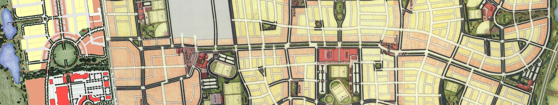
The first 3 phases of the development have been constructed and feature a number of innovations as well as set the stage for future phases.  It is safe, I think, to say that Markham Uptown can be distinguished by one leading characteristic.   It is a Complete Community. 

IMG_0978IMG_1839_edited

Much has been said in recent years about ‘complete streets’ but it occurs to me that complete streets aren’t even possible in the context of suburban intensification, without first delivering ‘complete communities’.

Markham Uptown is such a community.

The first 3 phases have delivered all of the ingredients that I suggest are vital to the creation of a complete community.

They are:

  • Land uses are mixed to include employment, office, retail and residential.  An elementary school will be provided in future phases as will an office precinct at the west end of the site opposite City Hall Other land uses such as community centers and high schools are provided on other lands within Markham Centre as a whole.

IMG_1826_edited

  • City blocks are a very pedestrian friendly 90 – 120m long.
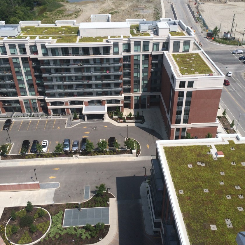
  • Building loading and servicing areas are screened from view and are assembled along a private laneway which also helps to break up the blocks into smaller architectural units.
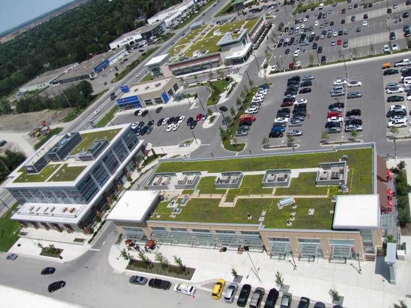
  • The first main street (Birchmount Road) is animated on both sides with at grade retail
  • The retail is supported by on-street parking as well as interior parking lots that are mostly screened from public streets by built-form and landscaping.
  • Bicycle lanes are a dedicated form of transportation on the major roads
  • The entire site is serviced by regular regional transportation and it is a 15 minute walk through the Rouge Valley to the Markham GO Train station to the south.
  • All buildings are LEED Gold and bird friendly
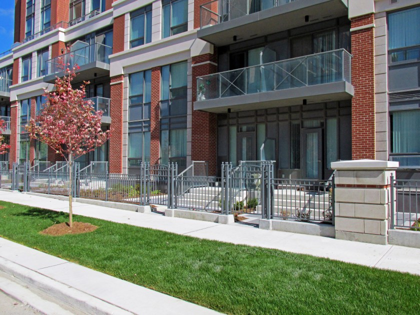
  • At grade residential uses animate the street with principle unit entrances, decorative fencing and gates.

IMG_0292_Revised

  • Extensive Green roof technology is fully employed in each phase

IMG_3203

  • Residential towers offer outdoor rooftop amenity spaces that overlook the Rouge Valley.

IMG_0975

  • Rain water harvesting on each block meets water balance targets and allows for storm water re-use in irrigation and building plumbing
  • LID initiatives include the use of permeable pavements, infiltration galleries and whole system cisterns that delay the reintroduction of storm water run-off into the Rouge River and allow for the settlement of particulates and the cooling of run-off.   These operate in place of the traditional storm ponds that are a maintenance headache and consume valuable land.
  • Street tree soil volume targets of 30m3/tree are met with either increased boulevard soil depths, or in the case of trees in pavement through the use of structural soil cells
  • The precinct is punctuated with 4 public open spaces.   Two 1 acre parkettes in the east and west neighbourhoods, a central plaza space which will serve as a focal gathering space for residents and a large east/west linear park that straddles the Rouge Valley.

There is little doubt that these features make Markham Uptown a unique development in the GTA, if not unique to the Province of Ontario and the country as a whole.  Markham Uptown will absolutely be made unique however, by its physical relationship to the Rouge Valley which bisects the Markham Centre lands.

support_rouge.jpg

The Rouge River is a large floodplain.   It is a wildlife corridor and important cold water fishery and it features a number of unique and rare plant species as well as geomorpholigical features.  It is also one of the key linkages in connecting the future downtown of Markham with Milne Dam Conservation Area and The Rouge Park to the east.

The plan for Markham Centre and Markham Uptown is to integrate the best of urban design with the very best in natural features protection and management.   This is accomplished through Markham Centre Greenlands Plan, prepared by our office.  After an exhaustive inventory and assessment of flora, fauna and hydrologic features, the greenlands plan recommended a number of interventions and improvements that would balance conservation and protection goals with  the inevitable demand for public access that would come with new development

These initiatives will be complimented by an interpretive program that heightens awareness around each unique feature of the corridor as well as preferred public protocols for interaction with the river.

The first phase of this work is now fully funded by the municipality and developer and will be undertaken in the not too distant future.

It is my view that Markham Uptown will be a uniquely complete community.  This is borne out by the success of the first three phases and the commitment of both the City and Developer to continue to ‘do it right’.   There is of course, more to do.

PROJECT TEAM

 Landscape Architecture and Urban Design:                    Schollen & Company Inc.

Architecture and Urban Design:                                Kirkor Architects and Planners

Planning and Urban Design:                                              Malone Given Parsons Inc.

Civil Engineering:                                                    SCS Development Consultants Inc.

Advertisement

The Perfect City Street

champs

About a month ago, I posted a question on my Facebook page which asked,  “What in your view, makes a perfect city street?”  Clearly an unscientific sampling, but I was amazed by the dozens of answers that I received.   They all spoke to characteristics that we can all easily visualize.

Here’s a sampling:

  • a residential street in Brooklyn Heights. Four story brownstones running down either side of the street and a row of old trees in front of each of them.”
  •  “Trees, wide sidewalks, bike lanes, short blocks, lots of pedestrians”
  •  “.an unintimidating scale, a few places where people can sit, houses, good sidewalks, street corners that are designed with all different ages and physical capabilities, bikes and motorists accommodated, definitely lots of trees,…”
  •  “Wide sidewalks, large tree canopy, outdoor cafes, cleanliness, good people watching!”
  •  “No above head wires ,or any wires whatsoever, good evening lighting….treed meridian…..cobble stones….Edinburgh new town crossed with Berlin”
  •  “Seating and a boulevard for kiosks and fountains. Go to Lisbon”
  •  “….trees, wide sidewalks, seating areas, elegant lighting, no overhead wires, bike lanes…”
  •   Trees!”
  •  “Quality shops . Outdoor cafe seating . Lighting and of course trees”

 There were a few themes common to the posts.   Not one of them mentioned ‘move traffic’ or ‘room for cars’,  though many talked about accommodating both cars and bikes.    Many of them talked about sympathetic architecture and land uses and almost ALL of them spoke to the importance of street trees!  This last point actually surprised me. It is also interesting to note that not one of these comments was from a practitioner.

This little survey got me to thinking.   What IS the perfect city street?   Is there any way to confirm that the design of a new street will meet the goal of a perfect city street?  Is  there any way to confirm that the design of a new street will meet the expectations held by the general public?

S:ProjectsConcord Floral 11060PRenderingPsd11084 - Masterpl

Streetscape planning and design is the most complex undertaking in urban design and landscape architecture.  It is so because it requires the successful reconciliation of the widest number of competing interests.   It is the only discipline in design that must successfully marry the following interests:

  • Land Use fit (particularly at street level)
  • Architectural fit (height, character, animation)
  • Right-of-way width, particularly in relation to architectural height
  • Day-lighting triangle dimensions and form (triangle vs. rounding)
  • Boulevard widths
  • Building Set-backs
  • Cross-walk design and placement
  • Accommodation of dedicated left and right turn lanes
  • Median design (where desired)
  • Roundabout design (where desired)
  • The design of abutting private landscapes
  • Transit infrastructure
  • Above-ground utilities
  • Below-ground utilities
  • Vehicular traffic and turning movements
  • On-street and adjacent parking
  • Bike traffic, comfort and safety
  • Pedestrian traffic, movements, comfort and safety
  • Street lighting and pedestrian way lighting
  • Street tree selection, spacing and sustainability
  • Low impact development infrastructure
  • Woonerf Design (where desired)
  • Street furnishings
  • Materials and finishes

It is also the only discipline within urban design where one wrong move by the designer, or domination of the process by one or more interests can compromise the goal of creating a ‘perfect street’.

This is not to suggest that there is one kind of ‘perfect street’, but rather that there are many, and the designers success will be tested by making appropriate decisions given the opportunities and constraints posed by the specific context and street type i.e. local, collector, arterial, retail, residential, mixed use etc.  It will also be determined by the degree to which all vested interests are prepared to compromise (more often than not this is the greatest single challenge).

In addition to this check-list of items to be considered, designers can find their way to a more ‘perfect street’ by reconciling competing interests and adhering to a number of guiding principles:

Ten Principles to Consider in the Design of Perfect Streets

  1. The height of buildings which frame the street must be directly proportional to the width of the right of way.   This is to say that a wide street with lower buildings will be infinitely less successful than a wide street framed by taller buildings.   The architecture frames the view of the street and provides a sense of enclosure.  It is therefore critical to its overall success of the street.   This is a law of minimums.Figure4-2 (The American Institute of Transportation Engineers “Designing Walkable Thoroughfares:  A Context Sensitive Approach” 2010)

    A generally accepted principle is that one should strive for a minimum ratio of 1:4 building height to ROW width. Preferred ratios can go as high as 1:2 building height to ROW width.  Note that in most city downtown cores the ratio of height to width is MUCH higher.  In these cases, the design of the street and boulevards becomes more important as the building wall can be perceived as overwhelming and therefore the pedestrian experience less inviting.

  2. If the street is proposed to have above ground utility poles or already has them…then do all you can to bury them.  This isn’t cheap, but they are an eyesore and upstage everything else that might be good about the street.  They will also limit the degree to which street trees can be used to help frame the street.  Utility companies have spent so much money ‘pruning for clearance’ that they have, in light of shrinking budgets, simply banned the use of large shade trees within their space.
  3. If the street is part of a larger community planning initiative, then strive for city blocks no greater than 90-120 metres in length.   This improves both vehicular and pedestrian permeability and allows for more corner land uses and building entrances that help to animate the street.  To the extent possible, make them full turning movement intersections.   This will help to slow traffic and make the intersections more pedestrian friendly
  4. The personality of a street will, to a large extent, be expressed as a function of the land uses that frame it.  A residential street will differ in both form and function from a retail/commercial street or a street dominated by office buildings. The land uses will also help to define the way a street will behave and therefore the menu of elements to be employed in its design.S:ProjectsMarkham Uptown Phase 1 (P) 29056PRendering0.09.23
  5. Ensure that residential buildings have a minimum 3.0 metre setback to allow for front yard landscaping, steps, fencing at gates etcetera.  On busier streets a wider set-back may be warranted to provide a greater sense of buffering.
  6. For higher density residential buildings strive for podiums with a number of individual residential entrances at grade.   Also strive for principle building entrances located at intersections.  This provides direct pedestrian access to transit and other street amenities.
  7. If ground floor retail/commercial uses are proposed, then absolutely try to provide on street parking.  This is vital to successful retail and serves the dual purpose of offering pedestrians a sense of protection from traffic.
  8. Pay particular attention to the introduction of dedicated right and left turn lanes at intersections.   More often than not, these ‘added lanes’ will be provided at the expense of the boulevards.  As an antidote to this problem, try to widen the right of way at the intersection so that the boulevards and associated streetscapes are not lost.
  9. Ironically, the thing that people want most (street trees) is one of the most difficult streetscape elements to provide.   Their long term success and sustainability will be based on numerous constraints including species selection, spacing, soil volume, access to water and drainage, conflicts with below ground utilities, and conflicts with sight lines and driveways.  Try to make street trees one of the first considerations rather than one of the last.30
  10. Bicycles.  Yes, the one area of continuing and on-going debate among transportation engineers, civil engineers and landscape architects.   I’m not certain the issues will ever be reconciled, but I suggest the following principles apply.   Bicycles are a mode of transportation and so they should share the roadbed with cars and transit rather than the boulevard with pedestrians.    Bike lanes should be grade separated from pedestrian walkways.  They should be a unique colour so as to heighten their profile relative to cars.

There are certainly more principles to be employed in the design of ‘perfect streets’ , but these I think,  represent the major considerations.

On Syria

AAEAAQAAAAAAAAUOAAAAJDU1MTJhNmM0LTc3NWUtNDg3Ni04MDk5LWNkOWIxZjQyNTg2Mw

I spend my life designing and building new streets. Streets just like this. When I see images like this it actually makes me ache. If we don’t help the people fleeing from this carnage then we have lost our way. Further…if we don’t find a way to stop this carnage, then we have no choice but to hang our heads in shame. And to be clear, it is not about the street. It is about those who inhabit it and bring it to life.

Queen’s Quay Key

AAEAAQAAAAAAAAKXAAAAJDIwMDFkY2M5LTFhN2MtNGJjNy1iNGZjLTYxZDU4NmZjNjgzNwThere has been considerable debate in the papers and on-line recently about the success/failure of the new Queen’s Quay streetscape. It is generally loved by urbanists yet the average Joe finds it confusing and the police have now dubbed it the most dangerous street in the city.

The design essentially separates all modes of transit into dedicated rights-of-way. Two lanes of car traffic next to two dedicated trolly lines next to two dedicated bike lanes, next to a pedestrian zone closest to the lake.

I had a chance to walk it’s length last night and I’ll say this. It IS dangerous. But not how you would expect.

The biggest problem seems to be that there is little separation between pedestrians and cyclists. In some cases there are street furnishings like benches and street lights, but in many others there is little more than a paving band to announce to pedestrians that they are about to get clipped by Toronto’s wannabe Lance Armstrong.  

The street was packed with pedestrians while cyclists, skate-boarders and skaters were zipping along in their lanes at very high speeds. The generally distracted and happy pedestrians often meandered into the bike lanes completely unaware that they were in danger. I saw several accidents averted by wits, citizenship and good luck.

 There is a generally accepted principle that bicycle traffic should share the same passageway as cars. This is particularly true where the use of bicycles is promoted as a means of commuting. The problem here is that the bicycle traffic shares the passageway with pedestrians. So I think it is both a grade separation and a location issue.

 Seems that a retrofit might be in order.+

UPDATE:   As I was saying…………….

http://metronews.ca/news/toronto/1439299/pedestrian-punches-cyclist-in-the-face-for-running-queens-quay-red-light/